
ResourcesGulf of Maine Library CollectionIdentification of Important Habitats in the Lower Casco Bay (Maine) WatershedChapter 13. Wading Bird HabitatsGeneral: Wading birds are conspicuous wildlife of Casco
Bay coastal and inland wetlands, and long have been regarded as biological
indicators of environmental quality. While several species of egrets and
herons nest in Maine, only the great blue heron (Ardea herodias)
is on the Gulf of Maine Council's list of species for designating Regionally
Significant Habitats. However, we used data regarding nesting colonies
including the other species also, since these sites are likely to be suitable
for all wading birds. The other species were: snowy egret (Egretta
thula), black crown night heron (Nycticorax nycticorax),
yellow crown night heron (N. nyctanassa), glossy ibis (Plegadis
falcinellus), little blue heron (E. caerulea), and cattle
egret (Bubulcus ibis). SOURCES OF BIOLOGICAL AND SPATIAL DATA : Data on Maine
wading bird colonies and coastal foraging areas were obtained from Brad
Allen (MDIF&W), Andrews 1990, Gibbs and Woodward 1984, Tyler 1977,
and Hutchinson and Ferrero 1980. A June 24, 1992 memo from Kyle Stockwell
also was used to update colony distribution; locations of two inland colonies
were provided by P. Bozenhart (MDIF&W). Additional information on
biological tolerances and requirements were taken from Short and Cooper
1985, Chapman and Howard 1984, Tyler 1977, Gibbs and Woodward 1984, and
from Gibbs et al. 1991. Biological coverages included the CWCA's (MDIF&W), eelgrass (DMR),
and wetlands (NWI). We also utilized MDIF&W MHVW's for assigning habitat
scores. Landcover was developed as part of this study (Chapter 4). Additional
spatial information included the coastal shoreline (OGIS), CMGE, and bathymetry
(both from MGS). HABITAT CONSIDERATIONS The importance of foraging habitat is related to intrinsic characteristics
(abundance of prey, accessibility of prey) and, for colonial nesting birds,
distance from roosts or colony sites. Accordingly, scores were assigned
in two phases: (a) by cover type, as indicative of foraging conditions,
and then (b) based on distance from known colony sites (Erwin et al.,
1993). The latter valuation method was supplemented by (c) "high" and
"medium" value wading bird habitat areas as assessed by the MDIF&W
(MHVW), and coastal areas in which wading birds were observed feeding
(Hutchinson and Ferrero 1980). A. Use of cover characteristics as an indicator of foraging value:
The MDIF&W (agency memo of 12-22-93) used three variables (percentage
of open water, wetland area, and diversity of wetland types) to rate particular
wetlands as important to waterfowl and wading birds. However, criteria
for wading birds may differ somewhat from those for waterfowl. Also, findings
of Gibbs et al. (1991) suggest that these variables are not consistently
associated with habitat use by wading birds (see
Table 5). Accordingly, size and configuration of wetlands was only
taken into account by giving special emphasis to the "moderate" and "high"
value wetlands so identified by MDIF&W (see below). As an alternative, the foraging value of wetlands were derived from NWI
types, and from available occurrence data. Certain ecological systems
were regarded as particularly productive or likely to host concentrations
of forage organisms on a cyclic (tidal or seasonal) basis. Thus intertidal
estuarine, palustrine, tidal riverine and littoral habitats were scored
relatively high, while intertidal marine and limnetic areas were accorded
intermediate scores. Emergent or aquatic vegetation (e.g., E2EM or E2AB)
also indicated highly productive conditions; unconsolidated shore or reef
offered moderate productivity but good exposure of prey, while scrub/shrub,
rocky shore, forested, or unconsolidated bottom were regarded as less
suitable from the standpoint of structure. The assignments of habitat
foraging values for wading birds, interpolated from these factors and
adapting the comments of Chapman and Howard and Gibbs et al., is shown
in Table 6. B. Distance from colony sites as a factor in foraging value of wetlands:
Wading bird colonies are located at sites remote from predators and disturbance,
yet within range of wetland foraging areas (Gibbs and Woodward 1984).
These distance factors were considered as a sequence of zones around known
colony sites. Habitat within the zone closest to the colony ("colony zone")
was rated high both to protect the colony, and because use of nearby wetlands
for foraging would minimize energy expenditure for the birds. More distant
habitats were assigned to "primary" and "secondary" foraging zones, having
correspondingly lower relative values. Wading bird colonies within 30 km of the study area were mapped as a
GIS coverage; all relevant colonies were on islands in Casco Bay.
The colony was then circumscribed by a primary foraging zone,
characterizing a "home range" for most of these species. Foraging distances
were estimated from discussions in Erwin et al., 1987. The cited flight
distances were generally (50-70%) less than 5 km; mean travel distances
for 4 species of egrets and herons "were all well below 5 km". Frederick
and Collopy (1988) also found daily travel distances of 5 km or less.
Short and Cooper (1985) rated foraging areas at 5 km at 1/2 the value
of those within 1 km, and at 10 km at 0.1 of the base value. Figures in
Gibbs and Woodward were considerably greater; from a mean of 6 km to a
maximum of over 30 km. They found a significant linear relationship between
the quantity of "marsh" within 25 km and colony size. Home range was further estimated by overlaying a GIS coverage of colony
sites on polygons from Hutchinson and Ferrero (1980) in which one percent
or more of the population of any wading bird species' was observed foraging
during the nesting season. A 10000 m (radius) buffer around all colony
sites was found to include these polygons, and this was used as the primary
foraging zone. All of the rest of the watershed within the lower 14 towns
lies within 25 km of island colonies (considered the secondary foraging
zone). Foraging habitats within the primary zone were scored higher than
those within the secondary zone. C. Further identification of foraging areas from aerial survey and expert appraisal: Two supplementary measures of wading bird usage were adapted from MDIF&W products. Coastal concentration areas (from Hutchinson and Ferrero 1980) used by wading birds were assigned scores based on number of wading bird species seen and number of seasons they were present. The basic unit was occurrence of 1% or more of the Casco Bay population of a species during any of six seasons of the surveys. MDIF&W Moderate and High Value Wetlands also were assigned scores
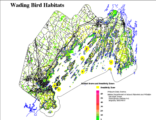
indicating an increased likelihood of use of these habitats. MAPPING OF HABITATS The final coverage was a composite of the values from the three data sources from (B) and (C) above (location with respect to the colonies, CWCA, and MHVW) and the "intrinsic" wetland scores from (A). For each wetland site, the overall score for wading bird foraging was the maximum from (B) or (C) times the "intrinsic" score based on NWI type. Nesting islands then were included, yielding a range of habitat quality scores from 8 to 4.
Colony disturbance or sensitivity zones were established as a buffer
around the nesting islands; the appropriate protective buffer distance
for colonies was estimated from the following. Watts and Bradshaw (1994)
observed that Chesapeake Bay wading bird colonies were located about 790
m from buildings, significantly different from the average of 460 m for
random points. Rodgers and Smith (in press) conducted flushing response
experiments and found that humans and boats could approach to within 125
m of wading bird colonies without overtly disturbing nesting birds. Management
guidelines from John Ogden, (ms.) recommend an 800 m buffer around woodstork
colonies. We also examined proximity of residential and commercial landuse
to seabird colonies along the Massachusetts coast. We measured distances
between colony sites and land use mapped at 1:24000, using GIS. Among
the 45 colonies including species other than cormorants and gulls, the
minimum distance to development was 700 to 1000 m. Based on this, we established
a colony sensitivity zone of 800 m. Bird use of foraging areas depends to some degree on isolation from disturbance
and maintenance of environmental factors such as water quality. Short
and Cooper (1985), in a habitat suitability model for great blue herons,
recommend buffering feeding areas at 100 m. Robert Buchsbaum (Massachusetts
Audubon Society, pers. com.), reviewing literature and his field observations,
offered tolerance distances ranging from 60 feet for great egrets to 300
feet for great blue herons. Bratton (1990) conducted a series of boat
intrusion experiments. She observed that egrets and herons were likely
to flush and leave foraging areas when a boat approached to within 60
m. Chapman and Howard (1984) noted that boating and other water activities
within 50 m are adverse for great egret nesting colonies. The development
of neighborhoods around foraging or nesting habitats may increase vehicular
traffic, and also offer a base for secondary disturbances from domestic
animals or recreational activities. Therefore, the sensitivity zone distance
should be larger than the minimum at which birds flush. MDIF&W buffers
moderate and high value riparian and wetland habitats at 250' (Jones et
al. 1988). We used a 30 m sensitivity zone for habitats which scored lowest,
and a 90 m zone (about 295') for the higher scored foraging habitats.
In all cases, the scores of foraging habitats within the sensitivity zone
distances of existing development were reduced to one-half the score of
pristine habitat. Areas which are currently developed were scored 0 (see
Figure 13). |