
ResourcesGulf of Maine Library CollectionIdentification of Important Habitats in the Lower Casco Bay (Maine) WatershedChapter 7. Black Duck HabitatsGENERAL: Waterfowl are important in Casco Bay from recreational
(hunting, viewing) and ecological perspectives. One of the species on
the Gulf of Maine Council's Species List for Identifying Regionally Significant
Habitats, the American black duck (Anas rubripes), is of special
interest, because of an historical decline in population. This analysis attempts to identify both marine (winter foraging) and
freshwater (foraging, nesting, brood-rearing and post-fledging) habitats
for black ducks, and sensitivity zones in which development may degrade
the adjacent habitats. These coverages are not intended to depict the
limits of areas being managed or those areas already under regulatory
control. SOURCES OF BIOLOGICAL AND SPATIAL DATA: Biological data
included the CWCA's (MDIF&W), eelgrass, shellfish beds and marine
worm harvest areas (DMR), and wetlands (NWI). MDIF&W identified Moderate
and High Value Wetlands for waterfowl from surveys made in 1974; we digitized
these wetlands by identifying the corresponding NWI polygons, transferring
them to a coverage, and assigning them the appropriate MDIF&W scores.
Landcover was developed as part of this study (Chapter
3). Additional spatial information included the coastal shoreline
(OGIS) and bathymetry (MGS). HABITAT CONSIDERATIONS Wintering: Black duck wintering populations in the Atlantic Flyway
are concentrated in marine, estuarine, and riverine wetlands extending
from the Canadian Maritimes through South Carolina. Rocky shoreline and
large tidal amplitudes are typical of marine wintering habitat northeast
of Cape Elizabeth, Maine. Black ducks loaf and feed on the southeast side
of islands and peninsulas, where there is maximum sunlight and protection
from wind (Longcore and Gibbs 1988). Black ducks also frequent ice-free
salt marshes, small tidal bays, and open waters of dynamic ecosystems
such as rivers and tidal inlets. Since black ducks are "dabblers", food
sources must be near the surface or just buried in the substrate (Lewis
and Garrison 1984). Black ducks wintering in coastal habitats feed mostly on invertebrates
living in rockweed or in shellfish beds on tidal flats (Jorde and Owen
1989). Diets differ due to habitat diversity, nutritional value of foods,
and different foraging patterns. Other seasons: Freshwater wetlands are used during the reproductive
period (courtship through post-fledging) and for general foraging or cover.
Black ducks generally prefer palustrine emergent wetlands for several
functions (Frazer 1988), but habitat selection also depends on season.
In the fall, palustrine scrub-shrub and forested wetlands receive more
use. Riverine wetlands become more important as ice forms on lentic habitats.
Less used, but still having functional value, are lacustrine and estuarine
wetlands. Black duck preferences for nesting habitat vary widely. They may nest
in upland areas near an ephemeral pool or other wetland, or up to 1.5
km from a water source (Jerry Longcore, FWS, pers. com.). Due to this
variability no attempt was made to map nesting habitats; it is assumed
that some nesting habitat will fall within areas mapped for other functions,
or within the sensitivity zones for those habitats (see below). Brood-rearing ducks consistently select habitats that will meet the energy
requirements of their growing young. Appropriate wetlands include those
with active beaver colonies, impoundment ponds, and open water within
palustrine emergent wetlands. Black ducks apparently prefer small wetland
areas for pair-bonding (USFWS 1988). They also utilize small (< 0.5
ha) ephemeral pools and small permanent ponds intensively during the nesting
season, as well as for stop-over points during overland movements with
broods (Ringelman and Longcore 1982). MAPPING OF HABITATS We used the above understanding of the requirements or preferences of black ducks to characterize the habitat values of potential wintering, foraging, brood-rearing, and post-fledging areas for black ducks. NWI wetland classes and other environmental themes were used to assign relative scores for each of these life stages. Wintering areas were further defined from CWCA polygons in which the population exceeded 1% of the seasonal total count. The 1% criterion reduced the scope of the analysis to habitats likely to be significant from a population standpoint. Inland habitats which were within MHVW polygons were regarded as more likely to be suitable, and so were given a higher score. Habitat characterization and the resulting scores or values are shown below. These scores were used when combining coverages for various species.
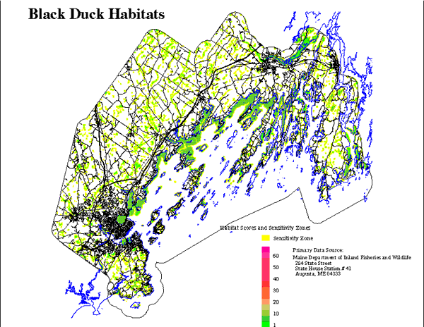
A protective or "sensitivity zone" was identified around black duck habitats
to indicate areas in which development and associated domestic activities
would be expected to degrade those designated habitats. Zone widths (30
to 90 m) were based on MDIF&W wetland buffers (Jones et al. 1988).
The final black duck coverage was adjusted to account for the effects
from existing development in the watershed. Habitats within the sensitivity
zone distances of existing development were reduced to one-half the score
of pristine habitats (Figure 8b). The steps in mapping habitats were: WINTERING COMPONENT: 1) select those CWCA polygons hosting => 1% of the Casco Bay total
black duck count. 2) select areas within these polygons that are <= 1 m deep. Assign
these a relative score of 4. This depth includes foraging areas accessible
to this species. 3) select areas resulting from step (2) which also have eelgrass, shellfish,
or are intertidal. Assign these a relative score of 8. 4) select areas outside the CWCA's, but which have eelgrass or
shellfish and are <= 1 m deep, or are intertidal. Assign these a score
of 4. While black ducks were not observed in these areas during the MDIF&W
surveys, they were scored for the presence of suitable food resources.
BROODREARING AND POST-FLEDGING COMPONENTS: 1) Select NWI polygons designated palustrine emergent. Where these overlap
a MHVW rated 2 or 3 assign these a score of 8, otherwise score as 6. 2) Select NWI polygons designated palustrine forested, scrub shrub, or
aquatic bed. Assign these a score of 4. INLAND FORAGING: 1) Select NWI polygons designated palustrine emergent, forested, scrub
shrub, or aquatic bed. Where these overlap a MHVW rated 2 or 3 assign
these a score of 8, otherwise score as 4. 2) Select NWI polygons designated riverine emergent or aquatic bed, or
lacustrine emergent or aquatic bed. Assign these a score of 4. COMBINATION OF HABITAT SCORES: 1) Identify sensitivity zones for the above; use a distance of 30 m for
areas scored 4 and 90 m for areas scored 8. Reduce scores for habitat
within this distance of existing development to one-half the score of
pristine habitats of that type. Areas which are currently developed are
scored 0. 2) Scores for the above habitat components were combined so that the
output at each locality was the maximum of the scores for these functions.
|