
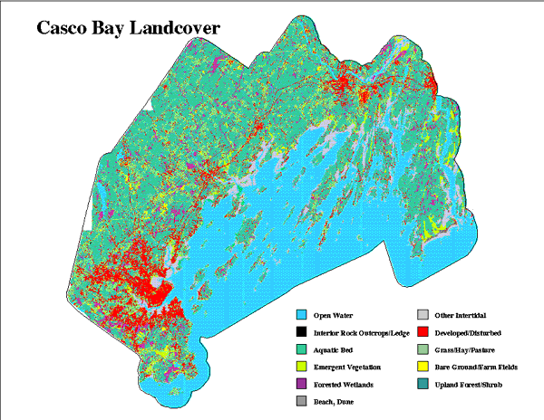
ResourcesGulf of Maine Library CollectionIdentification of Important Habitats in the Lower Casco Bay (Maine) WatershedChapter 3. Landcover of Casco BayGENERAL: Landcover information was initially developed from a June 6, 1991 Landsat TM scene provided by the Maine Office of GIS and processed by Earthsat Corporation, Rockville, MD. The intended classification included: two intensities of development (residential and commercial, or transportation landuse), beach or dune, rock outcrop or bare ground, intensive agriculture (row crops), orchards, improved pasture or grasslands, old fields, clear cut, deciduous upland shrubs or regrowth, deciduous upland forest, evergreen upland shrub or regrowth, evergreen upland forest, mixed upland shrub or regrowth, mixed upland forest, open water, sparse emergent (marsh) vegetation, dense emergent vegetation, submerged vegetation, scrub-shrub wetlands, forested wetlands, and mudflats. SOURCES OF DATA: Draft landcover products were received from Earthsat. Earthsat had aggregated a number of the classes which could not be distinguished with confidence; these were either dropped or were placed into the nearest related classes. We tested accuracy of the draft classification by comparing the interpretation to landcover information from other sources. The sources included 1) a 1972 polygon coverage encompassing about 35% of the study area (we used only polygons which had not changed according to 1991 aerial photography obtained from the Greater Portland Council of Governments), and 2) 1991 landcovers of Freeport and Brunswick, made from aerial photography by J.W. Sewell company. We examined the Earthsat interpretation within polygons selected from these two sources for covertypes of interest. The proportion of agreement was only 40 to 70%, depending on class. MAPPING OF LANDCOVER: Jed Wright (FWS) then created additional grids using ERDAS software and the same 1991 imagery. Difficulties again were found in distinguishing certain important landcover types. Accordingly, we combined three of the interpreted images, using the most accurate features of each. Accuracy of the landcover was incrementally improved by 1) dropping all wetland interpretation from the image processing, and using wetland data from National Wetland Inventory digital maps; 2) aggregating classes in which confusion remained excessive and which did not need to be distinguished for the current project; 3) replacing or augmenting coastal upland and intertidal features with overlays derived from Coastal Marine Geologic Environments (CMGE), and 4) directly editing certain features which were clearly distinguishable on aerial photos, but confused in the digital processing. The final classes were: developed/transportation, grass/pasture, rowcrop (agriculture), upland forested, upland rock outcrop, beach/dune, open water, submerged vegetation, emergent vegetation, wetland forested, and intertidal. Upland classes of the final products were examined with reference to the aerial photographs, and tested for accuracy using field ground-truthing sites initially collected for the use of Earthsat in image processing. Since we did not use them for classifying the image, they still served as independent data. Table 3. Results of Comparison Between Upland Classes in Final Grid LCNEW17 and Actual Field Sites.
* number of instances in which the classified image agreed with the ground-truth
determination. Since the locations of most of the wildlife habitats were mapped from other information sources (e.g., NWI, CMGE, bathymetry), our primary use of this landcover was in relating the proximity of habitats to development. The accuracy of the development signatures was generally quite good (see above). However, the high reflectance of coastal ledge caused it to be erroneously classed as developed; this formed an intermittent line along some shorelines. A portion of this error was corrected by reclassifying "developed" landcover cells falling within the areas CMGE designated as "ledge". The processing required development of 17 grids, plus many other intermediate steps, all of which FWS retains, archived on tape. Landcover map Figure 3a) |