
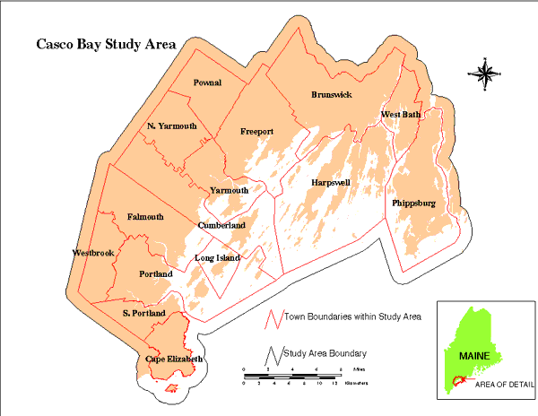
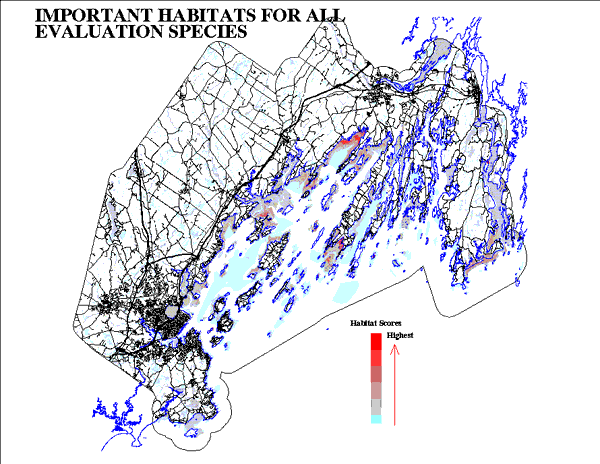
ResourcesGulf of Maine Library CollectionIdentification of Important Habitats in the Lower Casco Bay (Maine) WatershedChapter 1. Summary of the AnalysisStudy Area and Themes Portrayed: The evaluation species and the extent of the study area were determined cooperatively with the Casco Bay Estuary Project (CBEP). Based on the intensity of development and the coastal focus of CBEP, the study area included the lower or coastal 15 towns of the watershed (Brunswick, Cape Elizabeth, Cumberland, Falmouth, Freeport, Harpswell, North Yarmouth, Phippsburg, Portland, Long Island, Pownal, South Portland, West Bath, Westbrook, and Yarmouth). To insure that habitats near the outer boundaries of these towns were adequately assessed, we appended a one mile wide strip of neighboring land and water to the study area (Figure 1). In accordance with the focus of the National Estuary Program, evaluation species were those predominantly associated with wetland and coastal features. The FWS has particular interest in migratory wildlife, wetlands, anadromous fishes, and endangered species. The species for which habitats were identified included saltmarsh cordgrass, eelgrass, shellfish, commercially important marine worms, resident and migratory fishes, endangered species, waterbirds, seabirds and wading birds. Their selection was also based upon institutional, commercial and ecological importance (as evidenced by rank on the Gulf of Maine Council's Ranked List of Evaluation Species). We also required that sufficient data be available to insure that habitat maps could be produced and satisfy scrutiny of technical reviewers. Some species of high local interest, such as harbor seal, various marine fishes and American lobster were not selected either because they were not on the GOMC list, because of limited distributional information, or because they would not be sensitive to the development impacts being examined. In contrast, several of the avian evaluation species are at a high trophic level, thus relatively sensitive to perturbation and likely to be exposed to disturbance from development activities. General Methods For Habitat Characterization and Scoring: The analysis was conducted by use of a Geographic Information System. We identified important habitats in Casco Bay according to the aggregate of their values for each of the evaluation species. This was accomplished by creating gridcell maps of the study area in which each cell was evaluated and assigned a numerical score as habitat for each of the species, then combining the scores for each species by map overlay techniques. These scores were adjusted for relative scarcity of habitats and for the species' rank on the Gulf of Maine Council's list. The final map scores were the products of the scores for habitat quality, habitat abundance, and species rating (see Table 1). Information on habitat distribution and value for the selected species were derived from agency reports and digital coverages, where available; otherwise this information was developed as part of our analysis. First we created species profiles or habitat suitability models, reflecting habitat needs and tolerances. These models were entered into the GIS, and operated on digital environmental information to yield maps showing where suitable combinations of conditions occur within the species' range. Our data sources included scientific literature, advice from species experts, occurrence records (from surveys, collections, or incidental observations), and base maps of environmental information. We thus expanded upon the occurrence information to depict probable habitats, such as feeding areas for wading birds. Where information was less complete we used occurrence records (e.g., bald eagle nest sites) to depict habitat components. We also incorporated state designated significant habitats where this information was available, and gave these areas relatively higher habitat scores. These included Moderate and High Value Wetlands (MHVW), draft Maine Natural Resource Protection Act (NRPA) seabird islands, and MDIF&W Essential Habitats.. Sensitivity Zones: One of our objectives was to identify buffer or sensitivity zones in which development activities (human occupation, domestic animals, vehicular traffic) would likely affect the value of neighboring habitats. For each species, the extents of these sensitivity zones were based on disturbance distances derived from 1) technical literature, 2) analyses we conducted (identifying the observed minimum distance between developed land and occupied habitat), 3) expert observation, and 4) agency rules. Distances depended on habitat function (e.g., reproduction, foraging) and quality (greater distance for highest habitat quality). Sensitivity zone distances were used to assess impacts from existing development, and will be used to estimate potential impact from the buildout analysis. Assigning of Habitat Scores: The habitat scoring for each evaluation species was similar to the process used in the FWS Habitat Evaluation Procedures (1980). One or more habitat components were identified, based on biological function (reproduction, foraging). Suitability of these components was assessed according to the presence, absence, or level of relevant environmental factors (for example, vegetation type, depth, substrate). Habitat suitability was numerically scored or indexed on a fixed scale. We gave the top quality habitats (or habitat components), based on the occurrence of optimal conditions or highest actual level of use, a score of 8; average quality habitats (intermediate habitat conditions, probably or potentially used) were scored 4, and non-habitats scored 0. Adjustments to Habitats Scores: 1) Just as sensitivity zones were extended around habitats, so impact zones were extended out corresponding distances from existing development. Developed areas (land surface dominated by paved surfaces or buildings) themselves were regarded as having no habitat value for the evaluation species. Habitat scores within the relevant impact zones were reduced by half, based on infringement by development and associated activities. 2) We indexed the habitat scores for the species according to their ratings on the Gulf of Maine Council's list (see Table 1). The evaluation species all are prominent in regard to the institutional, socio-economic, and ecological factors considered in that list, and so rated between 5.1 and 7.2 on a scale of 0 to 8. 3) Scores were reapportioned to increase values for relatively scarce habitats, and correspondingly decrease values of habitats which were more abundant in the study area. Thus shorebird habitat was accorded higher value per unit area than the more abundant waterbird habitat of the same quality. In the same way multiple component habitats (for instance, nesting and foraging components for wading birds, seabirds, or roseate terns) were further apportioned relative to a hypothetical 50 - 50 division. While we lacked information on the biologically appropriate amount of each component, it seemed reasonable that the relative importance of the components would be related to their abundance. For example, loss of 1 out of 1000 acres of feeding area would probably be far less damaging than loss of 1 acre out of 5 acres of nesting colony. Accordingly, we raised the relative scores of the habitat components in limited supply and reduced the scores of the abundant components. Habitats were indexed inversely to the most abundant type, on a 0.8 - 8 scale ( Table 1). Draft species/habitat profiles and habitat maps were sent to species experts for technical review. Intermediate and final maps were displayed and discussed at two technical workshops. Comments and advice have been incorporated in the final analysis. Aggregation of Scores: A final habitat map was created by multiplying the habitat quality, species rating, and habitat abundance scores for each species, then adding these products. This final product (Figure 15) sums the scores for all evaluation species, indicating areas having the greatest values for the largest proportions of these species. While this clearly discloses areas having high habitat value, it is important to keep in mind that a) other areas are likely to be important to an alternative suite of species (e.g., terrestrial plants, songbirds, mammals, marine fishes), and b) the evaluation is a synthesis of the best available information but may not accurately portray most recent conditions or actual occupation by the evaluation species. Field verification of habitat conditions and use by the evaluation species is indicated prior to management actions. |