
ResourcesGulf of Maine Library CollectionIdentification of Important Habitats in the Lower Casco Bay (Maine) WatershedChapter 10. Roseate Tern HabitatsGENERAL: Roseate terns (Sterna dougallii dougallii), a state and federally listed endangered species, utilize certain coastal islands and inshore waters of Casco Bay. The two most important nesting islands for roseates in Maine are Eastern Egg Rock and Petit Manan Island, although the Sugarloaf Islands (at the eastern edge of our study area) were important sites historically and "could be the site of a restoration project" (Stephen Kress, Nat. Audubon Soc., pers. com.). Limited information from banding recoveries indicates that these roseate terns winter along the north coast of South America, and may remain there for the first and even second year of life (Ralph Andrews pers. com.). In Maine, roseates nest with the more aggressive common terns (which assists in nest defense) and also with arctic terns. Suitability of nesting sites is limited by many factors. These include appropriate vegetation, proximity of feeding areas, and absence of nesting gulls, humans, and predatory mammals and birds (Ralph Andrews, Steve Kress, pers. coms.). Jeff Spendelow (Patuxent Res. Center, pers. com.) stated that "good foraging sites for prey to feed the young" may be a major or limiting factor in maintenance of colonies.
SOURCES OF BIOLOGICAL AND SPATIAL DATA : Data for the
tern coverages were obtained from the MDIF&W 1994 Essential Habitat
maps, CWCA coverage, MDIF&W Seabird Island Database, and Andrews (1990).
The federal Recovery Plan for the roseate tern (Andrews et al. 1989) contains
data summaries and extensive discussion of management needs and actions.
Biological sensitivity and requirements were derived from reports of Nisbet
(1989), Shealer and Kress (1994), and Heinemann (1992). Additional spatial
information included the coastal shoreline (OGIS) and bathymetry (MGS).
HABITAT CONSIDERATIONS While records are available of roseate tern nesting in Casco Bay, we
were not able to locate information on roseate tern foraging locations.
Our primary data source for occurrence of marine wildlife, the CWCA coverage,
does not list terns by species. Therefore, we developed a GIS coverage
of potential roseate tern foraging habitats from surrogate information,
taking into account the roseate tern's preferences. The following factors
were considered: Feeding range: Roseate terns may fly considerable
distances from nesting or roosting sites to feed. Heinemann (1992) observed
11 and 16 km flight distances between a major roseate tern nesting colony
at Bird Island, Massachusetts and its two primary feeding sites. Jeff
Spendelow (pers. com.) noted that foraging excursions may, on occasion,
be up to 50 km round trip. This information suggests that foraging areas
located within 15 km of nesting islands may be suitable. Feeding site fidelity: Ann Kilpatrick, (McKinney NWR, pers. com.) noted that the same sites off the north shore of Long Island were used day after day by birds from Faulkner Island, Connecticut. Nisbet (1989) noted that feeding by roseate terns around Buzzards Bay, Massachusetts, was generally restricted to a few specific areas; these did not change over a span of 10 years or more. At Petit Manan Island (Maine) roseates were observed to feed exclusively over a shallow bar between Petit Manan Point and Green Island (Nisbet 1989). Accordingly, specific foraging areas may be used persistently, and may be mapped for protection and management.
Feeding associates: Ann Kilpatrick, Shealer and Kress, and Andrews
et al., observe that feeding flocks often are dominated by the far more
abundant common terns. Heinemann described four types of roseate tern
foraging behavior: shoal feeding - (in less than 3 m depth, but adjacent
to deep water), feeding over shallow flats - (in less than 2 m depth),
school feeding - (predator fishes driving forage fishes to surface along
deep edges of shoals), and over feeding cormorants - (terns follow cormorants
and capture fishes driven to the surface). Feeding environment/prey: Jeff Spendelow commented that foraging
frequently occurs at tide rips (typically where current flows over shallow
bars), in relatively sheltered areas. Ann Kilpatrick found that the major
prey at Long Island Sound sites was sand lance situated over shoals. Tom
Halavik (FWS, pers. com.) notes that sand lance commonly are found at
river mouth sandbars and shoals, and also as migrating pods. Young of
the year summer in the surf zone, then settle a few hundred yards offshore.
Heinemann (1992), working in Buzzards Bay, Massachusetts, reported that
95% of roseate's prey was sand lance in early summer, and herring (3 species),
mackerel, and bluefish later in late summer. Nisbet (1989) also found
that feeding was mostly on sand lance, but also on anchovy. Shealer and
Kress (1994) observed foraging by roseates during the post breeding and
pre-migration period (late July and August) at Stratton Island, Maine.
At this time roseate terns fed almost exclusively on sand lance in Saco
Bay (just south of Casco Bay), although other prey were available and
were taken by common terns. Feeding typically occurred in < 10 m depths,
over sand. Andrews (pers. com.) and Kress (1993) identified young white
hake, pollack and herring as important foods for mid-coast and northeast
Maine colonies. MAPPING OF HABITATS Nesting Islands: These were mapped directly from MDIF&W roseate
tern Essential Habitats and the MDIF&W Seabird Island Database. Jane
Arbuckle (pers. com.) submitted that persistent nesting by common terns
may indicate suitable roseate nesting habitat. Three islands in Casco
Bay supported common terns during both 1976 and 1984 surveys. Two of these
were already Essential Habitats; Grassy Ledge (the third island) was added
to our nesting island coverage. Outer and Inner Green, East Brown Cow,
and White Bull Islands also were important nesting islands for common
terns, historically (Stephen Kress, pers. com.). While these are not currently
suitable for roseate terns, these islands are recogized as valuable habitats
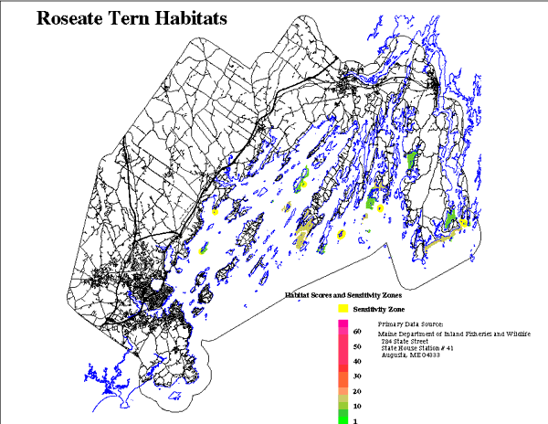
for other seabirds (see Chapter 11). Foraging Habitats: A GIS coverage of potential roseate tern foraging
habitats was developed from the CWCA coverage, based upon 3 attributes:
proximity of polygons to roseate tern nesting islands, suitability of
water depth, and foraging by species that feed in association with roseate
terns (based on Heinemann 1992). In Maine Cormorants and common terns
are far more abundant than roseate terns. Therefore, mapping the distribution
of areas used by feeding associates is likely to be conservative (include
or overestimate roseate tern feeding areas). Combined nesting and feeding
habitats are shown in Figure 10. The steps were:
1) select polygons from the CWCA coverage which were within foraging
range of known and potential nesting colonies (15 km). 2) from the above set we selected polygons used by foraging associates (terns and cormorants). CWCA polygon attributes include average count by season for each species. During the nesting and post-nesting season (May 1 to August 31, inclusive) the average count per observation for all terns (species not identified) was 7; for cormorants the average was 42. We selected polygons within foraging range for which there were: a) an average count > 6 terns for any season and there was
not a contiguous tern nesting island or a beach on which least terns nest.
This requirement reduced inappropriate identification of foraging areas
when birds really were present only because they were nesting nearby.
Score = 4. b) alternatively, polygons were selected which had an average count
of > 41 cormorants for either the nesting or post-nesting season, and
there was not a contiguous cormorant nesting island. Score = 4. c) if both terns and cormorants were feeding in an area score = 8. d) additional CWCA polygons were included, based on observations of
roseate tern feeding by Jane Arbuckle (pers. com.); score = 8. 3) from the above set we retained areas < 10 m deep. 4) portions of nesting islands and feeding areas which are currently
developed were scored 0. The resulting GIS coverages are intended as representations of environmentally
suitable land and water areas for roseate terns but are not intended
to depict areas being managed or under regulatory control. |