
ResourcesGulf of Maine Library CollectionIdentification of Important Habitats in the Lower Casco Bay (Maine) WatershedChapter 11. Seabird HabitatsGENERAL: In addition to wading birds and the roseate
tern (analyzed separately), seven seabird species were common to the Gulf
of Maine Council's list of species for designating Regionally Significant
Habitats, and the MDIF&W Seabird Nesting Island Database (the primary
data source for this theme). However, only two of the seven (common eiders,
Somateria mollissima, and common terns, Sterna hirundo)
nest on Casco Bay islands. MDIF&W uses seabird nesting as a basis
for designation of "Significant Wildlife Habitats;" islands proposed for
such designation (draft NRPA islands) were added to the coverage even
if none of the constituent species were on the Gulf of Maine Council's
list. In addition to nesting habitat, this analysis identifies aquatic habitats
(foraging and probably resting) for eiders and terns, and sensitivity
zones in which development can be expected to degrade the adjacent habitats.
These coverages are not intended to depict the limits of areas
being managed or under regulatory control. SOURCES OF BIOLOGICAL AND SPATIAL DATA : Data for all
islands within or bordering Casco Bay were obtained from the MDIF&W
Seabird Nesting Island Database. Foraging and resting areas were determined
from MDIF&W's CWCA coverage. Additional spatial information included
the coastal shoreline (OGIS), bathymetry (MGS), and shellfish and eelgrass
beds (DMR). HABITAT CONSIDERATIONS Eider: The common eider is a large, social sea
duck with circumpolar distribution (Blumton et al. 1988). It breeds on
small coastal islands in the Gulf of Maine. Guillemette et al (1993) noted
that common eiders feed along rocky shores, diving for blue mussels, urchins,
and crabs. They prefer shallow waters over kelp beds where their prey
is most abundant; in the Gulf of St. Lawrence these areas occur at depths
of 0 -6 m. Goudie and Ankney (1988), however, note that apparent interspecific
competition between 4 species of wintering sea ducks displaced eiders
from some shallow foraging areas. They characterize eider foraging depths
in the presence of other sea ducks as -3 m down to -10 m. Tern: Common terns also nest on small coastal islands, and also
on islands in some large lakes (Veit and Petersen 1993). Nesting terns
often are displaced by gulls from the most favorable insular sites. Terns
feed on small fishes, often over tide rips (typically where current flows
over shallow bars), in relatively sheltered areas. Prey items include
young herring (Clupea), mackerel, bluefish, sand lance, and anchovy
(Heinemann 1992). MANAGEMENT CONCERNS Human disturbance can be a problem for either species, reducing availability
of foraging areas or driving birds from nests and thus increasing exposure
of young and eggs to predators. Therefore, we mapped zones within which
development would likely degrade value of the adjacent habitat. Nesting: We used the literature and available data sets to assign
sensitivity distances for individually for terns and eider nesting islands;
we did not assign a sensitivity distance specifically for draft NRPA islands.
Erwin (1989) found that nesting common terns and black skimmers flushed
when approached within 200 - 400 m. He recommended that a 200 m buffer
be established for human intrusion near colonies. While a 200 m zone may
be sufficient as a human approach- distance for common terns, development
is likely to prolong and increase the types of disturbance. We used GIS
to examine distances between developed lands and seabird colonies along
the New Hampshire, Massachusetts, and Maine coast. We found the closest
that common terns nested to an industrial site was 260 m, while the minimum
distance between residential land uses and nesting birds was 480 m (45
colonies examined). We selected a 300 m sensitivity zone for sites on
which common terns nested. None of the common tern nesting sites in Casco
Bay occur this close to development. Blumton et al., (1988) developed a nesting habitat model for the eider
which included sensitivity to human disturbance as a factor. Their optimal
distance from permanent human settlement was 2 km or more. The minimum
distances observed between eider colonies and development in Casco Bay
are 580 m (Crow Island-Great Diamond), 410 m (Pinkham Island-South Harpswell),
and 490 m (Seal Island-Small Point). Because the minimum distances
still may be relatively stressful, we rounded the minimum up to 500 m
for sensitivity zones around nesting islands for eiders. Feeding: available data did not allow us to examine proximity
of foraging sites and development. One can argue that birds can more readily
abandon foraging areas than nest sites, since the former involve less
of an "investment". We generally accepted the MDIF&W disturbance distances
(Jones et al. 1988), using a 30 m sensitivity zone for relatively low
value foraging habitats, and a 90 m zone for moderate or high value foraging
habitats. MAPPING OF HABITATS The steps in mapping habitats were: EIDER FORAGING:
1) Select polygons from the MDIF&W CWCA's hosting 1% or more of the
total eider count for the study area, for any of the survey intervals.
The 1% criterion reduces the scope of the analysis to habitats likely
to be significant from a population standpoint. 2) Select areas within these polygons that are <= 10 m deep. Assign
these a relative score of 4. 3) Select areas having mussel beds, eelgrass beds, or other submerged
vegetation within the polygons from step (2). Assign these a relative
score of 8. 4) Select areas outside the CWCA's that are <= 10 m and have mussel
beds, eelgrass beds, or other submerged vegetation. Assign these a relative
score of 4. EIDER NESTING: 1) Identify islands with 1% or more of the Casco Bay total eider nest
count. Assign these a relative score of 8. COMMON TERN FORAGING: 1) Select polygons from the CWCA coverage hosting 1% or more of the study
area total tern count, for any of the 3 seasons during which they occurred
there. It was assumed that the unidentified terns counted in this coverage
were predominantly common terns. Assign these polygons a relative score
of 4. COMMON TERN NESTING: 1) Identify islands with 1% or more of the Casco Bay total tern nest
count. Assign these a relative score of 8. OTHER SEABIRD NESTING ISLANDS: Assign draft NRPA islands a score of 8. ADJUST FOR IMPACTS FROM EXISTING DEVELOPMENT: Reduce the foraging habitat values by half if within impact zone around
existing development: zones are 30 m for habitats scored 4, 90 m for areas
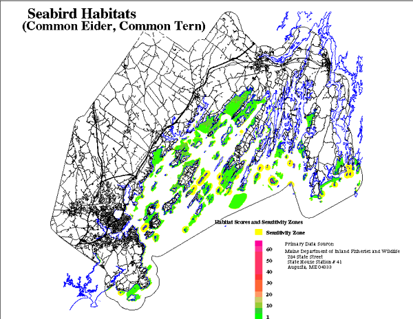
scored 8. Areas which are currently developed were scored 0. The combined habitats for eiders and terns are shown in Figure
11. |