
ResourcesGulf of Maine Library CollectionIdentification of Important Habitats in the Lower Casco Bay (Maine) WatershedChapter 14. Freshwater and Anadromous Fish HabitatsGENERAL: Lake and stream fisheries are ecologically
important in the Casco Bay watershed and serve as significant recreational
assets. MDIF&W developed a fisheries habitat appraisal method (MDIF&W
1989) which combines environmental characteristics, recreational values,
and relative abundance of fish species to yield a numerical estimate of
fisheries value. These numerical scores were regarded as the primary measure
of value for resident fishes; other data were used as surrogates, as described
below. Our evaluation also considered anadromous and catadromous fishes species,
those dependent on both fresh waters and the ocean. Nine species were
common to the available databases and the Gulf of Maine Council's Species
List for Identifying Regionally Significant Habitats. These were: alewife
(Alosa pseudoharengus), American eel (Anguilla rostrata),
American shad (Alosa sapidissima), American smelt (Osmerus
mordax), Atlantic salmon (Salmo salar), Atlantic tomcod
(Microgadus tomcod), brook trout (Salvelinus fontinalis),
redbreast sunfish (Lepomis auritus) and shortnose sturgeon (Acipenser
brevirostrum). Anadromous and resident species were given approximately
equal weighting in the overall stream habitat ratings. SOURCES OF BIOLOGICAL AND SPATIAL DATA General: Most of the fisheries assessments and
the basic sampling data on Casco Bay stream and lake fishes were obtained
from Owen Fenderson and Richard Arsenault of MDIF&W. Information on
anadromous fishes was digitized from Eipper et al. 1982. This publication
did not consider striped bass, (Morone saxatilis) another important
anadromous species which occurs in coastal inshore waters and downstream
of dams in the Kennebec and Androscoggin rivers (Flagg 1994, Flagg and
Squiers 1995). Casco Bay, and the Kennebec River in particular, supports
a highly significant striped bass recreational fishery. The omission of
this species did not affect the outcome of the analysis, however, since
both rivers were regarded as highly important fisheries habitats based
on their value to other species. Landcover was developed as part of this study (Chapter 4). Digital representations
of the Casco Bay coastline, ponds, lakes, streams and rivers were obtained
from OGIS. NWI and CMGE were used to identify intertidal and subtidal
areas within the lower reaches of major rivers. Stream fisheries: Biological and ecological
data on streams in the lower 15 towns of the Casco Bay watershed were
obtained from MDIF&W records held at Gray, Maine; we entered these
into a digital database. Most of this information is based on surveys
carried out in 1986/87, which documented biota, water chemistry, and stream
structure at one or more characteristic sites along most of the major
streams and rivers in the watershed. Data from each sample site was applied
to upstream and downstream reaches having the same name, or down to tidal
waters. Attributes included: date of collection, stream name, MDIF&W
number, town, sampling location, length and width of sample area, substrate,
temperature, pH, conductivity, alkalinity, riparian cover, and numbers
of fishes, invertebrates, and reptiles collected. Several digital databases were provided by Owen Fenderson, MDIF&W,
Bangor, Maine. These listed names and locations of most of the permanent
streams and characterized sport fisheries of the major streams, rivers
and lakes. These databases and information from more extensive local MDIF&W
records were combined to form attributes for an overall stream fish GIS
coverage. Stream use by anadromous fishes was added from Eipper at al.
1982, and Card et al. 1981. Lake fisheries: Data were obtained from the MDIF&W
Lake Inventory (1993 Format), a statewide database containing fields for
water chemistry, recreational characteristics, and fish species. Each
of 60 species was rated as either not known to be present (0), present
(1), present as a significant fishery (2), or being stocked (3). The Inventory
was supplemented by a fisheries database, focussed on recreationally important
species ("Occurrence of Fishable Populations"; data set FISH.FISHERY,
supplied by O. Fenderson). The databases were combined by assuming that
each species from the latter was "present as a significant fishery". Overall,
data was available for 16 lakes and ponds in the study area. HABITAT CONSIDERATIONS Stream habitat valuation: Habitat scores from MDIF&W were
available for most of the streams in the study area. For streams without
MDIF&W scores we developed a surrogate measure from the electrofishing
data set, based on counts of sport fish species. We first verified that
a positive and significant correlation existed between the MDIF&W
scores and sport fish counts for the 84 streams where both measures were
available. The score based on counts of species was indexed to match MDIF&W
range, and was used to complement the absent MDIF&W scores. To either of the above habitat scores we added a value for present or anticipated use by anadromous fishes. Nine species of anadromous fish were documented from the Casco Bay watershed; the number of species per stream was indexed to match MDIF&W range.
Lake habitat valuation: As with the streams coverage,
the MDIF&W habitat rating was used where available for lakes in this
watershed. Where not available, we substituted scores from another database
("FISH.LKVALUES" supplied by Owen Fenderson, MDIF&W) which listed
intermediate values from the MDIF&W habitat appraisal process. Alternatively,
to characterize lakes about which we had fisheries data but no appraisal
from MDIF&W, we summed the number of species present by lake and indexed
this to the maximum for any lake in the study area . MAPPING OF HABITATS Stream data: stream scores were the sum of the score from MDIF&W
habitat evaluation or, alternatively, the surrogate score we developed
from MDIF&W surveys, plus a score based on the relative number of
anadromous species. The sum of resident and anadromous values was indexed
on 0 to 8 basis. Stream boundaries were derived from stream and river
coverages (from OGIS). In coastal reaches, riverine subtidal areas were
assigned the full score, while adjacent intertidal flats were given half
the score. Lake data: lake habitat scores were derived either from (in order
of availability) 1) the MDIF&W rating, 2) the MDIF&W rating intermediate
values, or 3) the relative number of species present. These scores were
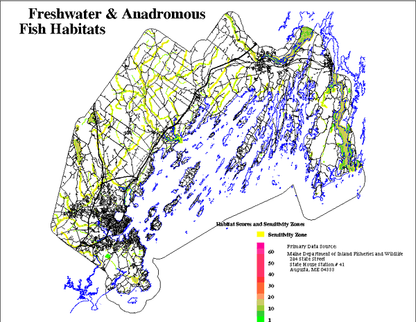
indexed on 0 to 8 basis. Sensitivity/protection zones: We mapped protection or sensitivity
zones peripheral to these habitats in which development activities may
be expected to affect fish habitat quality. We first attempted to identify
effects of existing riparian development on fish communities by relating
the fisheries data to the extent of development. Accordingly, we compared
the proportion of each subwatershed that was determined to be developed
or in agriculture (based on the landcover analysis), and the fishery scores
or composition of the fish communities for the associated stream. We also
compared the fisheries parameters for streams in relation to the proportions
of land developed within 180 m and 480 m wide corridors. Neither analysis
disclosed any significant relationship, probably because of data limitations.
Also, most of our fisheries data were from the 1980's, while the landcover
information is based on 1991 imagery. Finally, the precision of the landuse
determinations may be inadequate for this purpose. We finally adopted a rule-based approach based on MDIF&W riparian
distances (Jones et al. 1988). Protection or sensitivity zones were based
on the stream and lake scores; waters with MDIF&W ratings of F1 ("low
value") or occurrence of 1 to 3 anadromous species were given a 30 m (~100
') sensitivity zone. Higher rated waters were given a 90 m (295') zone.
To account for impact from riparian development, we scored fisheries habitat
within these distances from existing development one-half that for pristine
habitat (Figure 14). |