…for the sake of those who use it
Ocean observing sounds like something we’d all like to do – from the comfort of a beach chair on a sunny summer afternoon. But for the scientists at the Northeastern Regional Association of Coastal Ocean Observing Systems (NERACOOS), ocean observing is serious business.
They are responsible for collecting data from a series of monitoring buoys and producing information critical to mariners, fishermen, search and rescue personnel, coastal communities and others who live and work on or near the ocean – and doing it in real time.

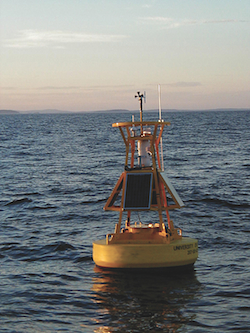
Figure 1. A NERACOOS buoy. (Photo by Neal Pettigrew, University of Maine.)
Ru Morrison, Executive Director of NERACOOS, sums up the work of the group as “using scientific information generated by the latest technology and models to make information people use on a day-to-day basis. I spoke to a fisherman at this year’s Maine Fishermen’s Forum who told me that the first thing he does every morning is to check the buoy data before deciding what he’s going to do that day.”
For the people who use it
What motivates Morrison’s work is “not just observing the ocean for the sake of observing it but for the sake of the people who use it.” Morrison said he knows of instances where buoy data has most likely saved the lives of those who might otherwise have gone out in unsafe conditions.
Describing himself as “an oceanographer who now drives a desk.” Morrison oversees an organization that spans a region from Long Island Sound to the Canadian waters of the Gulf of Maine and includes dozens of monitoring devices, collecting data on a range of parameters from current speed and direction to wave height, temperature and salinity.
But to say that NERACOOS collects and disseminates ocean data is to understate the work of this organization, work that goes on behind the scenes, largely invisible to users who frequent www.neracoos.org, or visit its Facebook page, for information on ocean conditions.
The raw data collected by NERACOOS feeds complex computer models that interpret the thousands of observations generated daily. These models allow NERACOOS scientists, working at research centers throughout the Northeast and the Maritimes, to create predictions regarding weather and ocean conditions.
As an example, Morrison describes the work of colleagues at the University of Massachusetts at Dartmouth “who manage a program that every night pulls together data from all the buoys – and other sources – to generate three-day forecasts not only of the weather but also of conditions up in the atmosphere as well as what’s going on below the surface.” The forecasts are made available on the NERACOOS web site.
Peter Smith, a scientist with the Bedford Institute of Oceanography (BIO) in Nova Scotia and a member of the board of NERACOOS, agrees with Morrison that “one of the real strengths of NERACOOS is that it takes science and makes it into a useful operational product.”
He describes a research project in the Bay of Fundy that is designed to create a new warning system for red tide. Collaborating with a team of scientists from BIO and the St. Andrews Biological Station (SABS) who have collected and analyzed a series of water samples, optical and other in situ measurements, Smith is working on a program that will allow NERACOOS to interpret satellite images of ocean color and predict the presence in the ocean’s surface layer of the red tide organism, known to scientists as Alexandrium fundyense.
Looking backward to look forward
The project involves calibrating the satellite images by comparing them to the water samples and establishing a relationship between the remotely sensed data and what was actually happening in the water. According to Smith, “comparing data looking backwards in time will allow NERACOOS to create a forward looking warning product.”

Figure 2. Seasons of the Sea exhibit. Photo courtesy of the Seacoast Science Center.
While such work is being done in other areas, the turbulent conditions in the Bay of Fundy, where huge tides stir up sediment into the water column, require that the work be tailored for local conditions.
The ability of NERACOOS to respond to local issues within the region – NERACOOS also oversees the use of a buoy to monitor nutrient conditions in Salt Bay in New Hampshire –is one of the strengths of a regional approach to ocean observing. It is highly unlikely that a nationally run program would be as nimble in addressing issues of such narrow geographic scope.
Just as NERACOOS coordinates the management of ocean observing platforms throughout the northeast, it is itself part of a hierarchy of ocean observing organizations across the country known as the Integrated Ocean Observing System (IOOS). IOOS, consisting of NERACOOS and 10 other regional ocean observing systems, as well as programs in several federal agencies, is coordinated by the National Oceanographic and Atmospheric Administration to ensure consistency in ocean observing throughout US marine waters and the Great Lakes.
NERACOOS, established in 2008, was designed in part to complement ongoing efforts to create regional ocean plans, as described in the newly-minted US national ocean policy. The Northeast Regional Ocean Council comprised of state and federal representatives and focused on regional ocean planning, recently signed an agreement with NERACOOS to facilitate the use of ocean observing data in its planning efforts.
Seasons of the Sea
One very public face of NERACOOS can be found at the Seacoast Science Center in Rye, New Hampshire, which also houses the offices of NERACOOS. Wendy Lull, the Center’s president, describes “Seasons of the Sea,” an exhibit at the Center that showcases NERACOOS data: “The exhibit illustrates the way scientists understand what’s going on in the water. It inspired a parallel exhibit on the atmosphere. Visitors learn about changes in the sea and the sky, changes mirrored in the view from the Center’s windows. From the exhibit, they can learn why the waves at Buoy B, for example, are the way they are.”
“More and more people understand that the oceans are in trouble – and they are asking questions. We want to make sure we give a reasoned answer,” said Lull. “We want to help people understand that their lives are influenced by the ocean – and that the way they lead their lives has a direct impact on the ocean.”
Describing Morrison as a “code breaker,” Lull waxes enthusiastic about the commitment of NERACOOS to the type of informal science education conducted by the Seacoast Science Center. Noting that NERACOOS “exists to provide services to the public; they want the public to use and appreciate their information”.
Having access to Morrison and other NERACOOS scientists represents an unparalleled opportunity for Lull to connect the public to the sometimes arcane world of ocean science and to connect NERACOOS to the public, perhaps its most important constituency.
“We translate for each other’s audiences, while sharing a mission of improving ocean literacy. It is critical that we have vetted data and that we can describe it in a way that inspires even greater curiosity on the part of visitors,” said Lull.
For his part, Morrison is proud of the “Seasons of the Sea” exhibit. “It was the first exhibit to bring real-time observing into an informal science education setting.” Given the commitment of Morrison and NERACOOS to translating ocean science into products useful for the public, it is unlikely to be the last.
Print


