The Casco Bay Estuary Partnership released the report “Climate Change in the Casco Bay Watershed: Past, Present, and Future” in late January. Based on historic climate change data for the Casco Bay region, and on work relating the predictions of global climate models to local conditions, the report reveals striking climate trends in Maine’s most populated watershed.
Overall, the region has been getting warmer and wetter over the past century, according to the report. Average annual temperature has increased nearly 2°F across the region. Ice-outs on Sebago Lake now occur nearly three weeks earlier than they did in the 1800s. Rainfall is on the rise, with Portland receiving nearly 20 percent more rain annually than it did one hundred years ago. The report also documents an increase in extreme weather events, a decrease in snow cover days, earlier spring run-off, longer growing seasons, and rising sea levels.
Projections for the future suggest those trends will continue. The report is designed to help municipal planners and officials make informed land-use and water management decisions.
“Our local partners indicated a need for locally relevant data on the effects of climate change, not just global or national averages.” said Dr. Curtis Bohlen, director of the Partnership. “We are pleased to be able to provide them with the information contained in this report.”
Mid-century temperatures are projected to increase by 20 to 60 F, and end-of-century temperatures by as much as 30 to 80 F. Summer temperatures may experience the most dramatic change, becoming up to 10°F warmer by the end of the century. Warmer, wetter conditions will make both floods and droughts more likely.
“Most Mainers aren’t aware of the potential risks of sea-level rise here in Maine,” Dr. Bohlen said. “We aren’t North Carolina, where huge areas of low-lying land would be submerged by even modest sea level rise. We think our rocky coast will spare us.” But that will not always be the case, he said. “All of Back Cove, and most of Commercial Street, is built on fill. Elevations are low; the land is flat. Those areas are likely to become much more vulnerable to coastal flooding as sea levels rise.”
The full report is available at the Casco Bay Estuary Partnership’s website, www.cascobay.usm.maine.edu.
The Casco Bay Estuary Partnership is comprised of local, state, and federal government organizations, nonprofit organizations, local businesses, and citizens. It is devoted to preserving the ecological integrity of Casco Bay and ensuring compatible human uses of the bay’s resources through public stewardship and effective management.

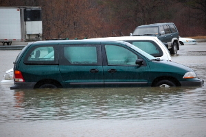
During the 2007 Patriot’s Day storm, flood waters inundated streets and parking lots around the Presumpscot River. A recent report indicates that extreme weather events like these are likely to become more frequent.


