By Anne Hayden
Conflicts over the appropriate use of the resources and habitats of the Gulf of Maine are nothing new, no doubt dating back nearly as far as the first human settlement along its shores. Historically, most such conflicts have been resolved in an ad hoc fashion, from the defense of local fishing territories to the resolution of the Canadian-American boundary dispute by the International Court of Justice.
In the first decade of the 21st century, a more comprehensive approach to conflict resolution has emerged, one that attempts to incorporate scientific knowledge regarding the structure and function of the Gulf’s ecosystem with a more systematic analysis of the range of uses and activities that provide the most benefit to the region’s residents and at the same time ensure long-term sustainability.

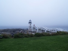
Marshall Point Lighthouse, Port Clyde, Maine. Credit: Nancy Griffin
Jessie Davies of St. Andrews, New Brunswick, helped lead the Southwest New Brunswick Marine Resources Planning Initiative, a multi-year effort to establish a vision for the Bay of Fundy, reduce controversy over use conflicts and provide community input into future development projects.
“It is all very tricky,” she said. “We need a strong economy, a vibrant ecosystem, and respect for historic traditions” but when conflict occurs “someone has to choose.”
Davies described the process as addressing “a lack of transparency and accountability in government agencies’ decision making.” The role of science was another area tackled by the Initiative.
Because “it is based on an oral tradition and not peer reviewed,” she said, “traditional knowledge does not get incorporated” in more formal scientific analyses but is an important component of community values.
The work of the Initiative involved establishing a process for identifying community values and priorities and publication of Preferred Future for the Bay, a report that sets out recommendations for how such values can be incorporated in government decision making.
Earlier this year, federal and provincial governments approved the establishment of an Advisory Committee that will meet three times a year, providing a forum for community-based discussion regarding use conflicts. As Davies points out, such a mechanism will also improve the process for those seeking permits for potentially conflicting uses by identifying local concerns early on in the permitting process.

Fishing gear in Gloucester, Mass. Credit: Nancy Griffin
On the US side of the Gulf, implementation of coastal and marine spatial planning (CMSP), a key strategy in the Obama administration’s National Ocean Policy (NOP), is proceeding. Released earlier this year, the National Ocean Policy Implementation Plan lays out national objectives and actions for coastal and marine spatial planning as a mechanism for implementing ecosystem-based management.
According to the plan, “uses of the ocean are expanding, and it is becoming increasingly challenging to effectively coordinate sometimes competing uses through traditional management approaches that historically were designed to manage single activities and sectors independent of other objectives. Today there is a need to consider human uses through a broader lens that more accurately reflects the connectivity and diversity of marine resources. To that end, an ecosystem-based approach to management is required, and an effective way to advance such an approach is through CMSP.”
Proposed actions include development of a handbook for regional coastal and marine spatial planning, the convening of regional workshops to conduct CMSP exercises, incorporation of federal data into an accessible data management system, the creation of regional planning bodies and the development of regional coastal and marine spatial plans.
US marine waters have been divided into nine planning areas; the Gulf of Maine falls in the Northeast planning region. The Northeast Regional Ocean Council (NROC), a state-federal partnership formed to address ocean and coastal issues, is leading an effort to implement CMSP in the Northeast. As initial ocean planning begins, NROC is focused on engaging stakeholders in the planning process, establishing a regional data management system and developing a baseline assessment of the ecological, social and economic characteristics of the region.
John Weber, Ocean Planning Director for NROC, has been on the road meeting with groups with an interest in what happens in the Gulf of Maine, including the New England Fishery Management Council (NEFMC), the Massachusetts Ocean Advisory Commission, Rhode Island’s Fishery Advisory Board, the New England Charter Boat Association, and representatives of the offshore energy industry.
He has presented at the Maine Fishermen’s Forum and met with the fisheries director in each New England state. NROC held a workshop in March as a kick-off for ocean planning in the region. It was attended by over 200 people, including representatives of the energy, aquaculture and fishing industries, New England’s ports and state and federal agencies.
According to Weber, “The whole effort is just starting. We want input on the goals before they are decided, including our approach to engagement.”
Some stakeholder groups in the Gulf of Maine are having their own conversations regarding CMSP in order to prepare for participation in the regional planning process. The Gulf of Maine Research Institute (GMRI) in Portland, Maine, held a meeting in February to foster discussion of the upcoming CMSP process among fishermen, inviting Weber and other NROC representatives to the discussion.
At the time, Kate Burns, former Director of Community Initiatives for GMRI, said fishermen believed there had not been a sufficient process to engage their industry. In discussing concerns fishermen had with a perceived top-down approach to the NOP, she said they didn’t like it “because of where it came from and how it came down to us, but they were trying to be constructive; they need to know how the process is going to work.”
A problem Burns noted is that the CMSP process doesn’t align geographically with the jurisdictions of the New England Fishery Management Council (NEFMC) or the Atlantic States Marine Fisheries Commission (ASMFC), the two regional bodies responsible for fisheries management in the Gulf of Maine. Fishermen expressed concern that a regional plan will have no binding authority on federal agencies and, as a result, the effects on their livelihoods are hard to predict. They also worried about the validity of the data on which a plan would be based. The CMSP process should not “assume that the data they get is accurate,” said Burns. Yes, despite their worries, Burns said of fishermen, “they’d rather have a plan than no plan.”
The Commonwealth of Massachusetts adopted the nation’s first ocean management plan in 2010, which provides a comprehensive approach to protecting marine resources and fostering sustainable uses in state ocean waters.
To support the development, implementation and revision of the ocean plan, in January of 2012, a new version of the Massachusetts Ocean Resource Information System (MORIS) was released. MORIS is a web-based coastal mapping tool that provides detailed geographic data for ocean planning, along with many other uses, and allows anyone with access to the web to search the system’s data layers, download the actual data for use in a Geographic Information System (GIS) and print and share maps. While designed for coastal management professionals, MORIS can be used by anyone interested in these data and maps.
Marine planning is a brave new world for much of the Gulf of Maine community but opportunities are not lacking—at local, state, provincial and federal levels—for those who want to learn more about and engage in the process.
Since March, Weber has met with more fisherman and said talks with fishermen will be ongoing throughout the process. On July 26, the President’s Chair of the US Council on Environmental Quality (CEQ), Nancy Sutley hosted a roundtable in Boston on the NOP and the work of the National Ocean Council Joined by NOC Director Deerin Babb-Brott, CEQ Chair Sutley engaged with local representatives in a discussion about ocean planning and coastal issues in New England, including offshore wind and fishing.
Websites:
http://bofmrp.ca/home/National Ocean Policy Implementation Plan
http://www.whitehouse.gov/administration/eop/oceans/implementationplanNortheast Regional Ocean Council
http://collaborate.csc.noaa.gov/nroc/default.aspx
Gulf of Maine Research Institute
www.gmri.org
Massachusetts Ocean Management Plan
http://www.mass.gov/eea/ocean-coastal-management/mass-ocean-plan/
Massachusetts Ocean Resource Information System
http://www.mass.gov/czm/mapping/index.htm


